
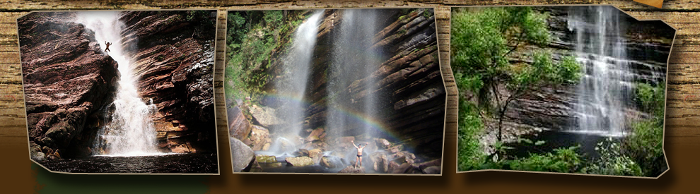

The Chapada Diamantina´s National Park
The Chapada Diamantina´s National Park has 152.575,00ha and is situated on the northeast of the Sincorá´s Mountains. It´s in the Bahia´s state centre and embodies 5 cities: Lençóis, Palmeiras, Andaraí, Mucugê and Ibicoara. Lençóis, the city that has the best tourism structure is 420km away from Salvador. The map below divides the Bahia´s state in regions
Climate and Relief

The climate of the Chapada Diamantina is tropical half-humid, even so in some regions predominates the half-barren one. The altitude varies, since the park is a mountain region. Therefore, to enter in the park it is necessary to go up the mountain range, since the cities are below of these. The average is of 1.000 meters of altitude, but the lowest places are 440 meters and the highest approximately 1,600 meters of altitude. Outsidethe Park (west) is the highest peak of the Brazilian northeast, Pico do Barbado, with 2030 meters of altitude.
Vegetion and Geology

The National Park of the Chapada Diamantina is in a region of biomes transition; therefore it encloses open pasture areas, caatinga, rupestres fields and bushes of altitude. The most impressive in all that is to seeing the mixture of these biomes that form one of the most exuberant landscapes of Brazil.
It has endemic species that join others and form an exuberant scene that only who visits the region can have an idea. Bromélias, Orquídeas, Sempre Vivas and Canelas de Ema are abundant plants and easily found in the strolls.
Inside of the park the rocks most frequent are conglomerated, argilitos, silititos, arenitos and quartzitos, dominating the region of the mountain ranges. Around the park there are limy rocks, glacial rocks and primitive gnáissicos sediments. With little incidence it also has the recent sediments and volcanic rocks.
The mountainous landscapes of the Chapada Diamantina had been formed by the called phenomenon “soerguimento”, that occurs when pressures that come from inside of the terrestrial crust finish raising part of the surface. Finally the time is another responsible for the beautiful landscapes, since it cause dumb erosion and to the landscapes with rains and winds.
Apas and Municipal Parks
APA Iraquara-Marimbus

With 125,4 a thousand hectares the APA Iraquara-Marimbus engloba 5 cities: Sheets, Andaraí, Palms, Iraquara and Seabra. It was created in 1993 with the objective to guarantee the conservation of natural areas threatened by the occupation improper human being and thus to provide to the tourists a possibility to know the beauty of the region.
The part north, in Iraquara and Seabra is the region of the limy caves and Palmeiras it is the region of the most famous mountains, as the Camel´s Hill and the Father Inácio´s Hill, where the tourist flow is intense and has scripts daily. Already the region of Lençóis and Andaraí is the area called Marimbus, also known as mini-pantanal. The rivers Saint Antonio, Sao Jose and Utinga receives waters from the mountain ranges of the national park, amongst them of the rivers Capivara, Roncador, Caldeirão and Garapa and forms the landscape that attracts many tourists in daily scripts. The sanding caused by the sands that had gone down the mountain range because of mining activities provoked a great ambient impact, forming beaches.
Mucugê´s Municpal Park

The Mucugê´s Municipal Park, with 570 hectares, shelters and the Alive Museum of Garimpo, consolidating the cultural identity of the city, that was the first city of the Chapada Diamantina where diamonds were discovered, in 1844, initiating the diamond cycle in Bahia. In the Sempre Viva Project, also inside of the municipal park, is possible to see the Tiburtino and the Piabinhas waterfalls.
Fire

One of the main enemies of the park and the nature of general form is the fire. We know that it can occur of course, but the forest fires that had occurred in the park had been in recent years caused by the man. Many fires are intentionally, so it´s a crime and the responsible ones must be punished. Others, even so few, are accidental and can perfectly be prevented. Cigarettes must be extinguished with care and remaining portions of glass or aluminum must be carried to the city. To cook, the guide must choose an adequate place that does not represent risk of the fire propagation, as well as it must erase it before sleeping.
Chapada Diamantina´s History

In accordance with ROY FUNCH in the book One Guide For the Chapada Diamantina, Graphical and New Publishing company Ltda Civilization, 2002, the history of the human occupation occured in the region of the Chapada Diamantina with the exploration of the gold and the diamond. At the beginning of XVIII century, gold was discovered in the city of Jacobina, in the north of the Chapada Diamantina. Initially the exploration of the gold was clandestine, but from 1720 it was finally set free in the region of Jacobina. After four years the exploration in the south region of the Chapada was set free, where today is situated the city of Livramento de Nossa Sra. The gold exploration in Bahia tooked two more centuries, since XXth century the diamonds incidence declined.
But the diamond exploration begined in 1730, but it was made in illegal way and clandestine up to 1832. In this half time mines were discovered and the diamond character of the region was recognized. In 1844 a trader who was traveling through the villages of the region recognized the gravel that always he saw in the old chapada when he walked in the region of Mucugê. After some attempts had found diamond in the stream that cuts the city, and then started to explore the region. It did not delay until the notice spreads and many diamond washers started to arrive, populating and increasing the cities of the region. From Mucugê until Morro do Chapéu(Mount of the Hat, to the north) the people arrival was intensified and new villages had appeared, as Igatu, Andaraí and Lençóis, and this region that encloses the cycles of the gold and the diamond was known as Chapada Diamantina.
This race of people behind the “easy wealth” that the exploration of these materials also resulted in politics fights. This generated many conflicts and together with the decay of diamonds extraction it occurred the power dispute, which we can detaches Horacio de Mattos, an influential colonel proceeding from the Old Chapada, today the village of Brotas de Macaúbas. Through some conflicts and some alliances he gained much influence and when the Coluna Prestes passed thrgouh the region he was assigned by the Federal Government to pursue its troops. And he made it until Bolivia.
All this dispute of power had consequences that added to the fall of the diamond activity and left the Chapada Diamantina region economically overwhelmed. With the victory of the Republic in the Revolution of 1930 the Cel. Horácio de Mattos attended the pacification appeal and delivered the weapons. Oncee disarmed, Horácio de Mattos and other colonels were arrested and sent to Salvador. Under protests against their arrest, he was set free in 13 of May of 1931 and was assassinated two days later by a familiar of a victim who it made in the past.
With the overwhelmed economy and without leadership politics the region of the Chapada Diamantina enters in decay and its population starts to leave to coffee farms and mines in other states of Brazil.
With the mine activity prohibition, the habitants of the Chapada Diamantina had that to search other alternatives to support themselves. It appeared therefore the tourist activity and with it came the conflicts of a philosophy of ambient preservation with the traditional mine activity, that was responsible for an ambient degradation without size. Until then the idea of preservation of natural environments did not exist and the change that would occur to follow brought new people and with them new ideas for decrease or minimize the environmental problems. In the 90´s tourists started to arrive in chapada interested in the beauties of the mountains form the park, and then the Chapada Diamantina could leave the bad economic sitiuation they were in.
Nowdays minning inside the national park is forhibbided and you can still met diamond miners in the mountain ranges outside the park, but they extracts diamonds manually, without the help of a dredge (motor) that used to help them doing holes and this turned their work more tiring and less efficient. The miners are usually few and generally aged. They still represent some risk because they change the water way in the rivers and they put fire in the busches “to clean the land” and to work. But it is important to remember that they are the responsible ones for the tracks that Extreme EcoAdventure walks, since these old ways were tracks th flow off the diamonds, re-opened by us in our exclusive expeditions in “abandoned” ways.
Fauna

The Hunting, such as the fire, are the worst enemies to the wild life around. Until few yaers ago the fire was very common and it happened for a long time, killing or chasing the wild life away. And there is people hunting until today inside the National Park because there isn´t efective guard in it. Nowdays, we don´t hear the groups saying they met mammals or other big animals. The most comom animals we meet are: snakes, lizards, grasshoppers, diferent sort of rats, armadillos, bats and birds.
Bibliographic Reference:
FUNCH, ROY. Livro Um Guia Para a Chapada Diamantina. Gráfica e Editora Nova Civilização Ltda, 2002
